


• 2,553.1+/- Certified Organic Acres • 3,761.5+/- Irrigated Acres • 4,724.26+/- FSA Cropland Acres • 3,613 Water Shares • 1,503.3+/- Acres of Pasture • Tracts Ranging from 96-975+/- Acres in Size • Late Model Irrigation Pivots • Extensive Irrigation Improvements • 6 Tracts of Isolated LAWMA Shares

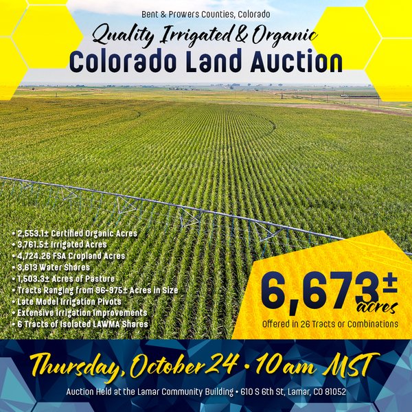
QUALITY IRRIGATED & ORGANIC COLORADO LAND AUCTION - 6,673+/- ACRES OFFERED IN 26 TRACTS OR COMBINATIONS IN BENT & PROWERS COUNTIES, COLORADO
Bent & Prowers Counties, Colorado
Owner: VCRAF AGIS Bent 50 LLC Thu, Oct 24, 2024 MOUNTAINAUCTION IS OVER
TOTAL SOLD: $14,680,000
| Tract(s): 1 | @ $975,000 | ($2,110/acre) |
| Tract(s): 2+18 | @ $2,000,000 | ($4,723/acre) |
| Tract(s): 3+6+7+11-13 | @ $1,125,000 | ($662/acre) |
| Tract(s): 4 | @ $1,400,000 | ($3,249/acre) |
| Tract(s): 5 | @ $1,100,000 | ($2,681/acre) |
| Tract(s): 8 | @ $810,000 | ($1,609/acre) |
| Tract(s): 9 | @ $275,000 | ($740/acre) |
| Tract(s): 10 | @ $825,000 | ($5,714/acre) |
| Tract(s): 14 | @ $800,000 | ($2,410/acre) |
| Tract(s): 15 | @ $1,900,000 | ($3,821/acre) |
| Tract(s): 16 | @ $590,000 | ($3,677/acre) |
| Tract(s): 17 | @ $1,040,000 | ($2,210/acre) |
| Tract(s): 19 | @ $900,000 | ($6,281/acre) |
| Tract(s): 20 | @ $540,000 | ($971/acre) |
| Tract(s): 21-26 | @ $400,000 |
Contact Auction Company for a Link to the Data Room or Hard Copy Information Booklet Containing Due Diligence Information!
OPEN HOUSE/INSPECTION DATES
Wednesday, September 25th from 3-6pm
Thursday, September 26th from 9am-12pm
Friday, October 11th from 3-6pm
Saturday October 12th from 9am-12pm
Tuesday, October 22nd from 3-6pm
Wednesday, October 23rd from 9am-11am
Held at the Historic Cow Palace Inn
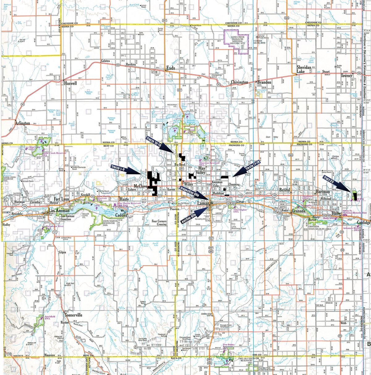
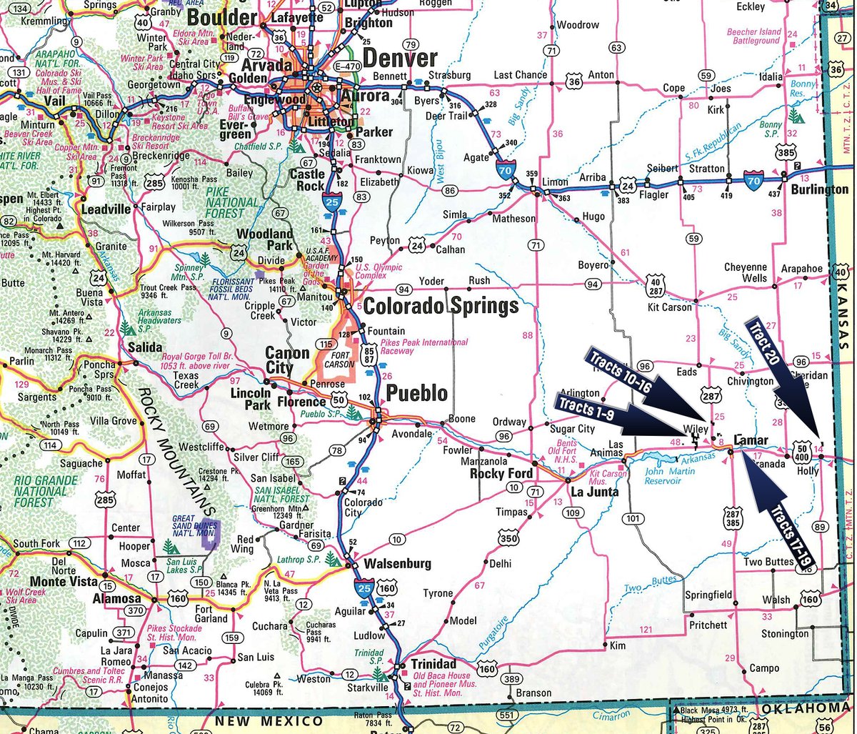
PROPERTY LOCATION
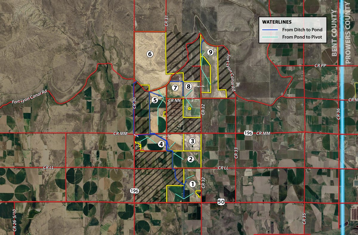
Directions to Tracts 1-9:
Tract 1: Located along US Hwy 50 1.5 miles East of the intersection of US Hwy 50 and Hwy 196 South of McClave.
Tract 2: From the intersection of US Hwy 50 and County Road 32 travel 1 mile North on County Road 32, the tract is at the NW corner of County Road 32 and County Road LL.
Tract 3: From the intersection of US Hwy 50 and Hwy 196 South of McClave, travel North on Hwy 196 for 3.5 miles and the tract will be on the South side of the road.
Tract 4: From the intersection of US Hwy 50 and Hwy 196 South of McClave, travel North on Hwy 196 for 1.8 miles and the tract will begin on the East side of the road. Continue through the curve to the East on Hwy 196 to view the rest of this tract.
Tract 5: From the intersection of US Hwy 50 and Hwy 196 South of McClave, travel North on Hwy 196 for 2.4 miles and the tract will begin on the North side of the road. Travel another 0.4 miles and turn North on County Road 31 to view the rest of this tract for another 1.4 miles.
Tract 6: From the intersection of US Hwy 50 and Hwy 196 South of McClave, travel North on Hwy 196 for 1.9 miles. Take a slight left and continue on County Road 30 for 1.7 miles then the tract will begin on the East side of the road.
Tract 7: From the intersection of US Hwy 50 and Hwy 196 South of McClave, travel North on Hwy 196 for 2.9 miles then turn North of County Road 31 and travel for 1 mile. The tract is located at the NE corner of County Road 31 and County Road NN directly North of the Beef City Feedyard.
Tract 8: From the intersection of US Hwy 50 and Hwy 196 South of McClave, travel North on Hwy 196 for 3.9 miles then turn North on County Road 32 and travel for 1 mile. The tract is located at the NW and SW corners of County Road 32 and County Road NN, as well as on the East side of County Road 32 just 0.2 miles North of the intersection of County Road 32 and County Road NN.
Tract 9: From the intersection of US Hwy 50 and Hwy 196 South of McClave, travel North on Hwy 196 for 3.9 miles then turn North on County Road 32 and travel for 1 mile. The tract will begin at the NE corner of County Road 32 and County Road NN.
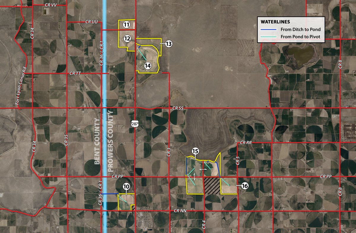
Directions to Tracts 10-16:
Tract 10: Located behind the Cross Plains Irrigation store at the corner of US Hwy 287 and County Road NN.
Tracts 11 & 12: Located at the NW and SW corner of US Hwy 287 and County Road UU.3.
Tracts 13 & 14: Located 0.3 miles South of the intersection of US Hwy 287 and County Road UU.3.
Tracts 15 & 16: From the intersection of US Hwy 287 and County Road PP travel East on County Road PP for 1.5 miles and the tract will be on both sides of the road. Travel another mile and Tract 16 will be on the South side of the road.
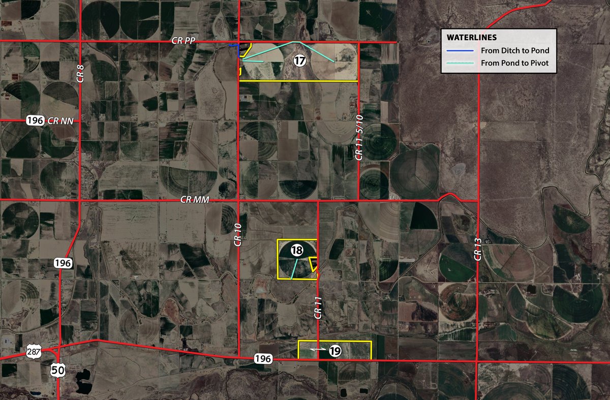
Directions to Tracts 17-19:
Tract 17: From the intersection of Hwy 196 and County Road 10, travel North on County Road 10 for 3.5 miles and the tract will begin on the East side of the road. Travel another 0.5 miles North on County Road 10 then turn East on County Road PP to view the rest of this tract for the next 1.5 miles on the South side of the road.
Tract 18: From the intersection of Hwy 196 and County Road 11, travel North on County Road 11 for 1.2 miles and the tract will begin on the West side of the road.
Tract 19: From the intersection of US Hwy 287 and Hwy 196 North of Lamar, travel East on Hwy 196 for 3.7 miles. The tract is located at the NW and NE corners of the intersection of Hwy 196 and County Road 11.
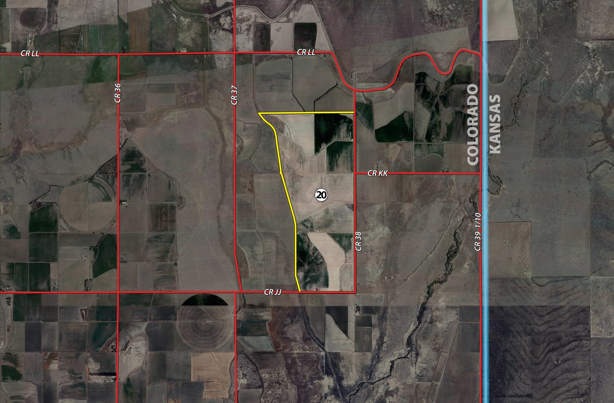
Directions to Tract 20:
Tract 20: From the intersection of US Route 400 and N 1st Ave in Holly, travel North on N 1st Ave for 3.3 miles then turn East on County Road JJ. Travel on County Road JJ for 2.5 miles and the tract will begin on the North side of the road. Continue on JJ for 0.5 miles and turn north on County Road 38 to see the remainder of this tract on the West side of the road for the next 1.5 miles.
AUCTION LOCATION
Lamar Community Building
610 S 6th St, Lamar, CO 81052
From the intersection of US Hwy 287 and E Olive St in Lamar, travel South on US Hwy 287 for 0.3 miles then turn West on W Pearl St and proceed for 0.1 miles. The venue is located at the SW corner of W Pearl St and S 7th St.
PROPERTY DESCRIPTION
Portfolio Summary: This Colorado Land portfolio is a unique and rare opportunity to acquire an expansive, irrigated, organic, tillable farmland package. The portfolio will be offered at public auction in tracts on October 24th via the M3 multi-tract method where buyers can bid on individual tracts, any combination of tracts or the whole portfolio. The irrigated farms contain impressive water infrastructure, mostly backed by the Fort Lyon Canal, and are coupled with late model pivots. Whether you are seeking additional irrigated acres, pasture or water opportunities, you will not want to miss this opportunity to place your price on high quality farms. Contact Schrader today to receive more information and a due diligence packet on this exclusive land offering!
Water Improvements: Extensive improvements have been made to the irrigation systems since acquiring the portfolio. Making the change from flood to center pivot irrigation on nearly all of the farms, maximizing water consumptive use has been improved greatly. The owners have focused on preserving the most precious resource in Colorado, water.
Sources: The portfolio has been built around a secure water system involving shares from the
Fort Lyon Canal Company (FLCC), Amity Mutual Irrigation Company (AMIC), Mutual Hyde Ditch Company (Hyde), Wheat Ridge Lateral Ditch Company (Wheat Ridge-Carrying Rights Only), and the Lower Arkansas Water Management Association (LAWMA). The number of shares with each water source can be seen in the charts associated with each tract. A complete Water Engineer report can be viewed on the website or by contacting the Auction Company. Water Stock certificates are also available for review.
History: The portfolio's water sources trace back to the Arkansas River. The Arkansas River starts in the Rocky Mountains of Colorado and flows easterly towards Kansas. Water diverted from the western slopes and regulation of the Arkansas River provides supplemental irrigation water for 265,000 irrigable acres in the Arkansas Valley. Because of this, the area has the ability to diversify the crops produced and meet peak irrigation demands.
A majority of the shares owned by the portfolio are specific to the Fort Lyon Canal. The Fort Lyon Canal is one of the most senior water rights in the Arkansas River System with decree dates in 1884. The Fort Lyon Canal is the largest and last river diversion before the John Martin Reservoir. By being positioned between the Pueblo Reservoir and the John Martin Reservoir, it is able to work cooperatively with six other major canal systems. By not requiring exchanges of water up the river, it is able to better maintain quality and quantity.
Pivots: All Valley Center Pivots, but one, have been installed between 2018 and 2021 and are in excellent condition. A table regarding the pivots location, towers and power sources can be found next to each property map.
TRACT DESCRIPTIONS
Tract 1: 462.1± ac with 306+/- irrigated acres and 259+/- acres under three Valley pivots supplied by 424 shares of Fort Lyon Canal Company water shares. This tract contains mostly Rocky Ford clay loam and Minnequa loam soils.
Tract 2: 269.4± ac with 196.5+/- irrigated acres and 162.5+/- acres under a Valley pivot supplied by 234 shares of Fort Lyon Canal Company water. This pivot contains mostly Numa clay loam, Rocky Ford clay loam and Minnequa loam soils. The Graveyard Reservoir on this tract also claims 23 LAWMA Preferred and 18 LAWMA Common shares.
Tract 3: 163.4± ac providing an opportunity to grow your dryland or grazing portfolio. This tract contains mostly Rocky Ford clay loam, Minnequa loam and Apishapa clay loam soils.
Tract 4: 430.9± ac with 351+/- irrigated acres and 299+/- acres covered by three Valley pivots supplied by 400 shares of Fort Lyon Canal Company Shares. Rocky Ford clay loam makes up the majority of the soil composition on this tract. Improvements include grain bins, a truck scale, shop buildings, an office, a rental home with a current tenant as well as two other homes. Bordering the town of McClave, there may be development opportunity!
Tract 5: 410.2± ac with 382+/- irrigated and 327+/- acres three Valley pivots supplied by 288 shares of Fort Lyon Canal Company water. This tract contains mostly Rocky Ford clay loam, Minnequa loam and Manvel silt loam soils.
Tract 6: 950.3± ac of pasture with quality perimeter fence. Utilize the multiple access gates on County Road 30 to utilize the native grass established in the Wilid silt loam, Manvel silt loam and Minnequa loam soils. The Kicking Bird Canal runs through the middle of this tract with the Fort Lyon Canal bordering the southern end of the pasture. Great opportunity to increase your grazing acres!
Tract 7: 205.9± ac containing Manvel silt loam, Limon clay and Rocky Ford loam soils. Utilize this tract to add dryland acres to your farming operation, or plant native grasses to increase your grazing acres.
Tract 8: 503.4± ac with 450+/- irrigated acres and 350+/- acres under four Valley pivots supplied by 262 shares of Fort Lyon Canal Company water. This tract is made up of mostly Minnequa loam, Rocky Ford loam and Rocky Ford clay loam soils.
Tract 9: 371.6± ac of well established native grasses containing mostly Minnequa loam, Rocky Ford loam and Apishapa clay loam soils. With existing corrals and multiple access gates along County Road NN, utilize this tract to increase your grazing acres.
Tract 10: 144.4± ac with 136+/- irrigated acres and 111+/- acres under a Valley pivot supplied by 144 shares of Fort Lyon Canal Company water. This tract contains primarily Rocky Ford clay loam soils.
Tract 11: 79.5± ac of dryland along Hwy 287 and County Road UU.3 containing mostly Wilid silt loam and Manvel and Minnequa loam soils. Bid on this tract to add dryland acres to your operation.
Tract 12: 182.5± ac of dryland along Hwy 287 and County Road UU.3 containing primarily Wilid silt loam and Rocky Ford clay loam soils. Combine tracts 11 and 12 for 279.5+/- acres of dryland to grow your portfolio.
Tract 13: 119.1± ac of well established native grasses growing in Wilid silt loam and Bacid silt loam soils. Utilize this tract for additional grazing acres.
Tract 14: 332.0± ac with 308+/- irrigated acres and 260+/- acres under a Valley pivot with a swing arm supplied by 200 shares of Fort Lyon Canal Company water. This tract contains primarily Rocky Ford clay loam soils. Utilize the house on this tract for rental income or hired hand housing.
Tract 15: 497.2± ac with 404+/- irrigated acres and 337+/- acres under three Valley pivots supplied by 341 shares of Fort Lyon Canal Company water. This tract contains primarily Rocky Ford clay loam and Numa clay loam soils.
Tract 16: 160.4± ac with 147+/- irrigated acres and 122+/- acres under a Valley pivot supplied by 150 shares of Fort Lyon Canal Company water. This tract is made up mostly of Rocky Ford clay loam and Numa clay loam soils.
Tract 17: 470.6± ac with 386+/- irrigated acres and 292+/- acres under two Valley pivots supplied by 251 shares of Fort Lyon Canal Company water. This tract contains mostly Rocky Ford clay loam and Manvel silt loam soils.
Tract 18: 154.1± ac with 146+/- irrigated acres and 114+/- acres under a Valley pivot supplied by a well with 151 LAWMA Common shares. This tract contains primarily Numa clay loam and Rocky Ford clay loam soils.
Tract 19: 143.3± ac with 129+/- acres being flood irrigated by 200 shares of Hyde Mutual Ditch Company water along with a well with 52 LAWMA Common shares. This tract contains mostly Las clay loam and Rocky Ford clay loam soils.
Tract 20: 555.9± ac with 420+/- acres flood irrigated acres by 420 shares of Amity Canal Company water containing primarily Rocky Ford clay loam and Nepesta clay loam soils. Although the water engineering report states 211 acres of this tract are being irrigated, all of the FSA Cropland acres are currently being flood irrigated.
Tract 21: 10 LAWMA Common Shares
Tract 22: 10 LAWMA Common Shares
Tract 23: 10 LAWMA Common Shares
Tract 24: 10 LAWMA Common Shares
Tract 25: 10 LAWMA Common Shares
Tract 26:
5 LAWMA Common Shares
The transfer of ALL water shares are subject to board approval. Please contact auction manager for additional questions.
TRACT MAP(S)
Tracts 1-9
Tracts 11-16
Tracts 17-19
Tract 20
PLAT MAP(S)
AREA MAP(S)
PROCEDURE: Bids will be taken on the individual tracts & any combination of two or more tracts. Bidding on individual tracts & combinations will compete until the end of the auction, at which time the final bid(s) will consist of that set of one or more bid(s) resulting in the highest total price. The final bid(s) are subject to Seller's acceptance or rejection.
PURCHASE CONTRACT: At the end of the auction, each high bidder will sign an offer in the form of the purchase contract included in each bidder's packet. All information contained in this sale brochure & other marketing materials is subject to the terms & conditions contained in the purchase contract. Seller & Seller's agents shall not be bound by any statement, promise or inducement that is not contained or incorporated in the written purchase contract.
PAYMENT TERMS: 10% of the purchase price will be due as an earnest money deposit, w/ the balance due in cash at closing. The earnest money deposit may be made in the form of cashiers check, personal check, or corporate check. BIDS ARE NOT CONTINGENT UPON FINANCING, so be sure you have arranged financing, if needed, & are capable of paying cash at closing.
DELIVERY OF TITLE: The property will be conveyed by Warranty Deed, subject to all easements & other Permitted Exceptions described in the purchase contract.
EVIDENCE OF TITLE: Preliminary title insurance schedules will be available to review prior to bidding. After the auction, Seller will furnish an updated title insurance commitment for each closing. At closing, Seller will pay for the cost of issuing a standard coverage owner's title insurance policy.
SURVEY: For any closing, a new survey will be ordered by an agent of Seller if & only if necessary to record the conveyance or otherwise deemed necessary or appropriate in Seller's sole discretion. If a new survey is obtained, the survey costs will be shared equally (50:50) by Seller & Buyer. Unless otherwise provided, the purchase price will be adjusted to reflect any difference between the pre-auction acre estimate & the gross acres shown in the survey.
CLOSING: Closing will be approx. 60 days after the auction (or as soon as possible thereafter upon completion of the survey, if applicable, the final title commitment & Seller's closing documents).
POSSESSION: Possession will be delivered at closing for tracts 3, 6, 7, 9, 11, 12, 13 & 20. Possession on the remainder of the tracts will be delivered subject to rights of the Lessee under an existing agricultural lease through 12/1/2025. (The lease is available to review upon request.)
WATER SHARES: The Water Shares shall be transferred to Buyer in accordance w/ the provisions of the purchase contract.
WATER ASSESSMENTS: Seller shall pay any unpaid Water Share Assessments attributed to the Water Shares for the 2024 water year or earlier. Buyer shall assume responsibility for all other Water Share Assessments associated w/ the Water Shares beginning w/ the Water Share Assessments for the 2025 water year.
REAL ESTATE TAXES: Seller shall pay the real estate taxes for the calendar year 2024 due in 2025 (or the estimated amount thereof) & all prior taxes.
MINERALS: The sale of the real estate will include minerals currently owned by Seller (if any). However, no promise, warranty or representation will be made as to the existence or value of any minerals or the nature or extent of Seller's interest therein.
TRACT MAPS; ACRES; ETC.: Advertised tract maps, acreages, square footages & dimensions are approximations & have been estimated based on county tax parcel data, property tax records, pre-auction survey work and/or digital aerial mapping.
AGENCY: The Auction Manager is the Seller's agent. Schrader Real Estate & Auction Company, Inc. is the Seller's transaction broker. Buyer will be treated as a customer & will not be represented by the Auction Manager or the Auction Company.
THIS PROPERTY IS OFFERED AS IS, WHERE IS, WITHOUT ANY WARRANTY OF ANY KIND AS TO ITS CHARACTER OR CONDITION OR ITS SUITABILITY FOR ANY USE OR PURPOSE. Prospective bidders are responsible for conducting their own independent inspections, investigations, inquiries & due diligence prior to bidding. All information in the marketing materials is provided subject to the bidder's independent verification. Seller & Auction Company assume no liability for any inaccuracies, errors or omissions.
CONDUCT OF AUCTION: The conduct of the auction & increments of bidding will be at the direction & discretion of the auctioneer. Seller & its agents reserve the right to preclude any person from bidding if there is any question as to the person's identity, credentials, fitness, etc. All decisions of the auctioneer at the auction are final.
CHANGES: Please regularly check www.schraderauction.com prior to the scheduled auction time for possible changes or additions to the property information.
AUCTION DAY ANNOUNCEMENTS WILL TAKE PRECEDENCE OVER THE MARKETING MATERIALS & ANY OTHER PRIOR STATEMENTS.


